If you’ve been keeping up with the news lately, you might be aware of the possible snow forecast for this upcoming weekend, and I’m sure I speak for many of us when I say I am more than ready for some frozen precipitation to fall. Unless you visit the mountains, you aren’t going to see much snow down here in the south, making this uncommon occurrence an exciting event for children of all ages. Memories of making snowmen, careening down glistening hills, and waging all-out-snowball-fight war with the neighbor kids permeate our minds this time of year as we hope for a rare snow day. However, South Carolina wasn’t always as barren of frosty flakes as you might think!
According to the South Carolina State Climatology Office, in 2014 South Carolina residents saw snow as early as November 1st, resulting in 3 inches of snow dusting the landscape in Lexington County. The largest snowfall in South Carolina occurred in 1969, when nearly 30 inches of snow fell on Caesar’s Head. The Blue Ridge Mountains, another feature of the Upstate, regularly see 12 inches of snow annually. So with these records of heavy snowfall in past decades and even regular snowfall in the mountainous regions of the Upstate, why have the past couple years been snow-free?
A WYFF4 weather forecast from February 2024 commented that this is the first time South Carolina has had two back-to-back years of no snow, and with the mild temperatures of December, it seems possible that this season may make it three. Meteorologists suspect the primary cause of the recent warmer winters to be the La Niña weather pattern. The terms “El Niño” and “La Niña” (literally translated to “the boy” and “the girl” in Spanish) refer to specific weather patterns that are influenced by Pacific Ocean temperatures. These names find their roots from when fishermen on the coasts of South America called the phenomenon “El Niño de Navidad”, as the El Niño cycle typically peaks around December.
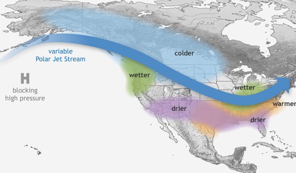
La Niña specifically represents the cooler period of the El Niño/Southern Oscillation (ENSO) cycle. This is the cycle of the warming and cooling of the Pacific Ocean’s surface temperatures, which in turn affects the atmospheric conditions over the Pacific, thus affecting global weather. During a La Niña period, the Pacific Ocean surface temperature is cooler, and this affects tropical rainfall from Indonesia to South America, influencing weather worldwide. In the US, we experience these effects the most during the winter months, when the disrupted atmospheric conditions cause the polar jet stream to move northward and weaken over the eastern Pacific. This results in heavy precipitation in the Pacific Northwest and warm, dry conditions in the southeast. Typically La Niña events occur every 3-5 years, but any given event can last for an indefinite period. Meteorologists at the National Weather Service predict that the ongoing La Niña event will neutralize by May 2025.
Thankfully, for those of us dying to freeze our fingers and toes in some icy slush, El Niño years are more common and essentially have the opposite effects of La Niña. Warm Pacific waters move southward, leading to wetter conditions over the southern US and Gulf of Mexico. Additionally, the polar jet stream’s relative position tips toward the south, and this junction increases the likelihood of snowfall.
In the end, while a white Christmas isn’t a staple classic of good old South Carolina, it never hurts to dream.


